

Full-day country walks in
SE England and beyond
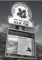
Edale to Hope via Mam Tor
Distance: 6.1 miles.
Time without long breaks: 4 hours.
Terrain: Some steep climbs and rocky paths.
How to get there and back: Catch a train to Edale station from Sheffield or Manchester. Return via train from Hope or catch a 272 or 257 bus from there to Sheffield.
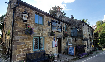
Pub breaks: Apart from the Ramblers at Edale, the only pubs are at the end of the walk at Hope. Our pick is the Cheshire Cheese. It also has the Woodruffe Arms and the Old Hall Hotel. If you fancy some non-alcoholic refreshments before starting the walk, we recommend the Penny Pot Cafe, which is adjacent to the south side of Edale station.
More information: A lot of the terrain on this walk is rough and rugged. Proper walking boots are a necessity. Although we walked it in winter, it's best not attempted if weather conditions are poor.
Click on the image below to access the full map on plotaroute

This spectacular and easy-to-follow walk through the Peak District National Park takes in some of Britain's best scenery. Starting at Edale, the route ascends from the village to the iconic peak of Mam Tor with its breathtaking views of the surrounding landscape. It then follows the Great Ridge Path, to Hollins Cross, Back Tor and Lose Hill. Descending from the ridge to the valley below, the walk concludes at Hope which has three pubs and good transport links.
Turn right when exiting the approach to Edale station (a popular alighting point for walkers, as the village marks the start of the Pennine Way). You will soon come to a junction by a red phone box. Turn right and then in 100m turn left by the National Trust sign for Hardenclough Farm. Follow the narrow lane, which heads towards the peaks, passing a farm on your right. As the lane starts to head uphill, it bends left and then right before reaching more farm buildings at Greenlands. There is a three-way footpath sign here. Follow the rugged track in the direction of Mam Tor via the wooden gate as indicated, with views of the Vale of Edale behind.

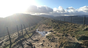
Leave Mam Tor from the opposite side to where you came from. As the path descends it merges with a bridleway to your left. Carry on along the stone-paved ridge path which has great views across the vale below. After just under a mile you will come to Hollins Cross, the lowest point on the Great Ridge. The cross no longer exists but the memorial pillar here marks the meeting point of multiple paths. Keep going eastwards along the ridge, heading uphill. The track becomes much rougher here and can be slippery in the wet. Carry on along the track, between a dry stone wall and a fence, passing through wooden gates at Barker Bank.
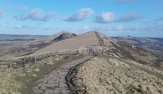
From the top of Lose Hill, follow the paved path as it descends southwards towards Hope. You will see the village ahead of you in the valley below, with a cement works to the right. Going through wooden gates, follow the broad track straight ahead, ignoring any turnings off, and proceed downhill towards Lose Hill Farm, passing a wooden signpost. The path goes round the back of what was the original farmhouse. Carry on heading south. You will soon pass a small stone barn on your left. Continue on the path, which crosses over several stiles and goes through some swing gates. About 1km from the barn, you will come to some buildings and a house on your right called The Meadows.

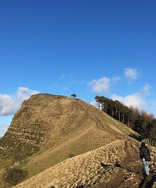
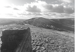
The bridleway heads steeply uphill at Cold Side, emerging at a hairpin bend in a road. Walk along the footpath that runs alongside the road by a wooden fence. Ignore the path that merges from your left, but keep on going around the bend in the road, with Mam Tor towering over you. You will soon reach a track with steps on your left. Take this and follow the stone path and the series of steps along the ridge to reach the summit and triangulation point, which has panoramic views from Kinder Scout to Stanage Edge and also across the Hope Valley. Be warned, it can get very windy up here!
Keep on the main ridge path, passing a footpath sign at a junction of tracks. Ahead of you there is a spectacular narrow ridge that leads to Back Tor. It's a steep climb up along an eroded path via some stone steps, but worth it for the views from the top of the outcrop. After Back Tor, carry on heading east along the ridge, proceeding uphill for half a mile to the summit of Lose Hill. The walk for the final section is made easier by stone paving. There is a tumulus here and a toposcope displaying the local landmarks. There is a great view of the ridge path going back to Mam Tor, so you can see just how far you've come to reach this point.

You have a choice here. You can either turn left along the lane and then, when you reach the road, turn right and go under the bridge to reach the Cheshire Cheese pub. From here, it's a short walk further down to Hope village centre. Alternatively, continue on the path ahead, crossing the railway via an odd sagging footbridge. The path goes through a patchwork of small fields via a series of gates before emerging next to a school. Turn left, then right at the junction. Buses to Sheffield (check Traveline for times) depart from opposite the church. The station is just over half a mile from here (about 12 mins walk). Turn left at the Old Hall Hotel and then after 700m take a left into Station Road.
The route of this walk follows what was once known as the Coffin Road. This is because coffins from Edale were once carried along the Great Ridge Path all the way down to Hope Church. So be glad you don't have to carry a coffin with you... Mam Tor means 'mother hill' and is so-called because landslides have created a series of smaller hills below it. The shifting shale also lends the landmark its alternative name of 'The Shivering Mountain'. The hill lies between the gritstone edges of the Dark Peak and the limestone plateaux of the White Peak, with the rocks here approximately 320 million years old. As incredible as it seems, the site was once inhabited (between about 1200 and 400 BC) and there are the remains of two hill forts – one dating from the late bronze age, the other from the iron age. There is also evidence that more than a hundred timber round houses were once built close to the summit and there are some bronze age burial mounds. As Julian Cope in The Modern Antiquarian, writes: 'How did people live on Mam Tor? It seems impossible as a home, so they must have had no choice whatsoever'.
Below the Tor are located four caverns: Blue John, Speedwell, Treak Cliff and Peak. The landslides here have been so bad that the A625, which used to run near the caves, has been abandoned – the route now continuing via B-road diversions. The other summit on this walk, Lose Hill, is also known as Ward's Piece. Eastwards across the river valley is Win Hill and Ladybower Reservoir. There are rumours that a 7th-century battle took place near here between Edwin of Northumbria, whose forces camped on Win Hill. and Cynegils of Wessex, who occupied Lose Hill. As Cynegils' soldiers advanced up Win Hill, Edwin's pushed boulders down the hill's slopes crushing the Wessex soldiers below and winning the battle. KB
Walks by County
Listed by the most traversed
county for each route
Berkshire
Buckinghamshire
Henley circular
Pr. Risborough-Wendover
Tring circular
Tring-Leighton Buzzard
Cambridgeshire
Cambridge-Trumpington
Whittlesford-Wandlebury
Derbyshire
Edale-Hope
Dorset
Corfe Castle-W. Matravers
East Sussex
Ashdown Forest
Berwick circular
Berwick-Seaford
Cuckmere Haven-E'bourne
Forest Row-Eridge
Glynde-Berwick
Glynde-Seven Sisters
Isfield-Lewes
Lewes circular 1
Lewes circular 2
Lewes-Hassocks
Lewes-Rottingdean
Plumpton-Hassocks
Rye-Three Oaks
Gloucestershire
Kingham circular
Toddington-Cleeve Hill
Hertfordshire
Codicote-St Albans
Odsey-Royston
Kent
Oxfordshire
Surrey
West Sussex
Bramber-Amberley
Steyning circular
West Yorkshire
Haworth-Hebden Bridge
Wiltshire
Avebury circular